


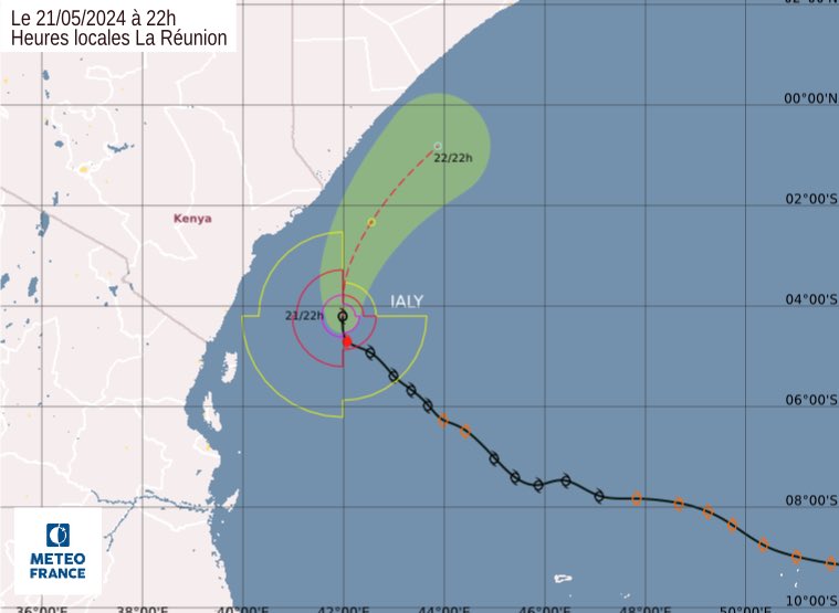
The weatherman has said Storm IALY intensified to the Tropical Cyclone stage on Tuesday, 21 May 2024, marking a historic event in the South-West Indian Ocean basin.
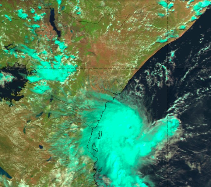
According to the Kenya Meteorological Department (KMD), the intense system, unprecedented in the satellite era, is positioned notably northwest of 5°S/45°E and remarkably close to the coasts of Kenya.
“The center of IALY is currently just 250 km from Pemba Island and less than 300 km from Mombasa,” the statement read in parts.
Besides, the weatherman explained that tropical cyclones within 5°S and 5°N are very rare.
However, peripheral bands of the system are beginning to affect parts of the East African coast.
“IALY is expected to weaken starting Tuesday evening and into the night, ultimately dissipating by Wednesday, while remaining offshore despite passing within 150 km of the Kenyan coast,” said Kenya Met.
Aftermath Tropical Storm IALY
The weatherman said waves of 1.5 to 3.6 meters are still expected along the Kenya coast.
Coastal areas of Kenya and neighboring countries will also experience moderate rain, storms, and windy conditions in the western periphery of the system.
“Expect strong south-easterly winds at 10-30 knots over Kenya and Tanzania waters due to tropical storm IALY,” the weatherman said.
“Wave heights will be 1.5 to 3.6 meters, with moderate to rough sea conditions. Small boats and crafts are advised to avoid deep-sea areas throughout the forecast period.”
Daily marine near shore Forecast for Kenyan Coast issued on 21st May 2024 and valid from 22nd to 23rd May 2024:
The daily marine near shore forecast for the Kenyan Coast predicts a breezy morning sea state with Southwest (SSW) to strong Southerly winds ranging from 10 to 30 knots on 22nd and 23rd May.
Also Read: Roofs Blown Away, Electric Posts on Fire as Storm Hits
Additionally, moderate choppy seas are expected, which may be dangerous for boats and other small sea craft.
“Waves from the southeast are forecast to reach heights of 5- 12ft, accompanied by large, short period waves of 8-9 seconds in Kwale, Mombasa, Kilifi, and Lamu counties,” KMD explained.
Kenya Met predicted that the sea state will remain breezy with SSW to moderately strong Southerly winds of 10-23 knots in the afternoon.
This will lead to moderate to choppy seas characterized by rough waves.
“Wave heights from the southeast are expected to decrease to 4-8ft with shorter periods of 9 seconds. Visibility is predicted to be moderate, ranging from 9 to 10 kilometers in Kwale, Mombasa, Kilifi, and Lamu,” said KMD.
Also Read: Kenya Met Warns of Another Cyclone Days After Hidaya Threat Faded
Kenya Met Directives
Residents, particularly in coastal regions and individuals involved in marine activities in the Indian Ocean, are encouraged to take maximum precautions.
They should stay informed by regularly checking the latest weather forecasts and updates from the KMD.
“Seek guidance from experts in relevant fields to mitigate potential impacts. Be vigilant and stay safe!” KMD advised.
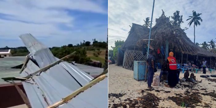
Strong Winds Experienced Along the Coast
Extremely strong winds were reported in various coastal areas of Kenya on Tuesday, May 21.
Kenya Red Cross reported that the winds were due to Tropical Storm IALY.
The strong winds blew off the roof of a residential house in the Majajani area of Kilifi County.
“Electric posts in Casuarina, Olimpia, Madunguni in Malindi and Garashi in Magarini, Kilifi County, fell down, while two posts in Jilore Trading Centre caught fire,” said Red Cross.
However, no casualties have been reported so far and the emergency team warned locals to take extra caution.
Follow our WhatsApp Channel for real-time news updates:
https://whatsapp.com/channel/0029VaB3k54HltYFiQ1f2i2C


Discussion about this post